Green - Overview
You are invited to meet some of the people and explore some of the places from Hebron’s past. This child friendly, family QR tour can be done in any order with each site being a short walk from here.
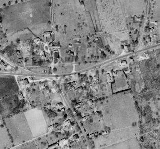
1930’s aerial view of Hebron Center. Notice how the forerunner of Route 66 was located more southerly than it is now.
Hebron Town Green
In the early 1700’s few people lived in Hebron center. Most people lived on individual farms scattered throughout Hebron. However, families gathered for Congregational Church services on Sunday, elections, town meeting day and militia training which was the origin of our term “Field Day”. In the 1700’s, farmers living nearby would let their livestock use the Green to fatten them up for markets as far away as Boston, New York and the West Indies. Usually, the town militia which was made up of men 16-60 trained on the town green. However, Hebron’s town Green was so rough that at times militia practice was held on Chestnut Hill near the town pound on Route 66 heading toward Marlborough. By the mid 1800’s, a civic improvement movement began to fill in the muddy spots, remove manure and trash heaps and make the Green look more like a park for people to stroll and relax in.
In the mid 20th century, as part of the Eisenhower highway system, it was decided to run Route 66 through the middle of the Green to attract more businesses to town. Route 66 and 85 did not substantially attract more businesses, but did fuel Hebron’s first suburban building boom resulting in subdivisions of old farms such as London Park close to the Bolton border.
Thinking about it
Hebron has a very small Green due to the highways passing through the town and the need for parking lots. If you had a chance to redesign the Green what would your new Hebron Green look like? Why did you make those choices?
Where to go next
Walk and take a closer look at the Old Town Hall

